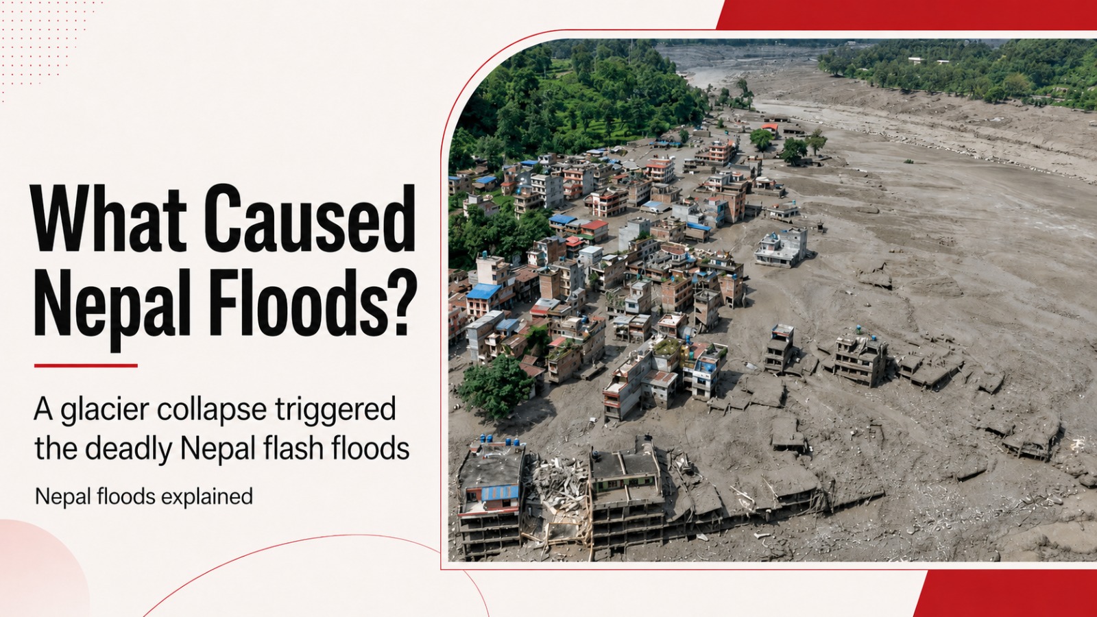
Nepal Floods: The disaster did not begin with heavy rain or an earthquake. Evidence points to a huge glacial collapse high in the Himalayas, followed by an ice-rock avalanche, a temporary river blockage and the sudden release of water, mud and debris into Nepal’s river valleys.
The devastating floods that tore through northern Nepal on Wednesday were not a conventional monsoon flood.
When the disaster began, reports from the region indicated it was not raining. Instead, the first major event happened thousands of metres above the settlements that would soon be hit.
At about 8:37 am local time on August 26, a large section of glacier broke away in the Himalayas near the Nepal-Tibet border. Satellite analysis indicated that the collapse began at an elevation of roughly 5,200 metres. The mass of ice then plunged about 1,200 metres towards the valley floor, gathering rock and sediment as it fell.
What followed was a chain reaction.
The ice-rock avalanche struck the Lhende River on the Tibetan side of the border. Debris temporarily blocked the river, creating a natural dam. When that blockage failed, the impounded water was released downstream with tremendous force.
That sequence is central to understanding what caused the Nepal floods.
It was not simply melting ice suddenly becoming floodwater. A collapsing glacier, falling rock, river water, sediment and a short-lived natural dam combined to turn an event high in the mountains into a fast-moving flood that travelled through populated valleys below.
What caused the Nepal floods?
The clearest reconstruction so far points to four connected stages.
First, a substantial part of a glacier became unstable and broke away.
Second, the falling ice picked up rock and sediment during its roughly 1.2-kilometre descent, creating a large debris avalanche.
Third, that avalanche reached the Lhende River and temporarily obstructed its flow.
Fourth, the natural blockage gave way, sending water and debris rushing through the river system towards Nepal.
The initial surge moved into the Lhende Khola and then through the Bhote Koshi and Trishuli river system. The Trishuli reportedly rose by as much as nine metres in only 30 minutes. Further downstream, the river system eventually connects with the Narayani, which crosses into India as the Gandak.
That helps explain how a disaster beginning in a remote Himalayan valley was able to affect settlements far downstream.
Why was an earthquake initially blamed?
The first reports created considerable confusion.
The event produced a strong seismic signal and was initially reported as a magnitude 4.4 earthquake. That led to early suggestions that an earthquake might have destabilised the glacier and triggered the disaster.
Further analysis changed that picture.
The United States Geological Survey examined nearby seismic stations, long-period seismic waves and satellite imagery and concluded that no earthquake had occurred. The seismic activity had instead been generated by the glacial collapse and debris flow itself.
The collapse ultimately generated a seismic event measured at magnitude 5.2. In other words, the mountain movement was powerful enough to look like an earthquake in the first readings, but the earthquake was not the trigger.
That distinction matters because it changes the understanding of the entire disaster.
The evidence currently points from glacier collapse to flood, not from earthquake to glacier collapse.
Why did the flood become so destructive?
The geography of the Himalayan border region made the consequences especially severe.
A large volume of material fell from high elevation into a steep river valley. Once the temporary blockage failed, the released water had little room to spread gently across the landscape. It was funnelled through narrow valleys and river channels.
The flood was also carrying far more than water.

Source: BBC
Mud, rock, ice and other debris were mixed into the flow. That gave the surge enormous destructive power as it moved downstream, striking buildings, bridges, roads and vehicles.
Videos from affected areas showed a moving wall of debris sweeping through settlements and river crossings. In Nepal, houses and roads were destroyed within seconds, while bridges along the Trishuli were washed away.
The damage spread beyond the immediate border area.
Rasuwa district, directly south of the Chinese border, was among the worst-hit parts of Nepal. Timure and Syapru Besi were affected, while flooding moved farther downstream into Nuwakot and Dhading districts.
At least 19 bridges and roughly 40 kilometres of roads were reported washed away, adding another problem for communities already cut off by the flood.
Was this a glacial lake outburst flood?
That has not been established.
Scientists were examining whether any glacial lakes drained during the event and whether water from rainfall or melting ice played a role in destabilising the glacier or surrounding ground. They were also studying where rivers became blocked and what conditions existed immediately before the collapse.
For now, the evidence supports a glacial collapse and debris-flow sequence followed by a temporary river blockage and its failure.
Calling the disaster a confirmed glacial lake outburst would go beyond what investigators had established by Thursday.
What role did climate change play?
This is where the distinction between a confirmed cause and a background risk becomes important.
Scientists had not established that climate change directly caused this particular glacier to collapse.
What is known is that the Hindu Kush Himalayan region is warming and its glaciers are losing ice. Scientists have also warned that warming can affect the stability of high mountain terrain.
One mechanism under investigation is permafrost.
Frozen ground can help hold steep mountainsides together. As that permanently frozen material warms, thaws and degrades, slopes can become less stable. Researchers were also considering whether meltwater or rainfall had entered cracks or weakened the ice and surrounding terrain before the collapse.
So the scientifically cautious conclusion is straightforward: climate change forms part of the wider environment in which Himalayan glaciers and mountain slopes are becoming more vulnerable, but a direct climate-change trigger for this specific collapse had not been proven.
That distinction should not be lost.
There is strong evidence for rapid warming and glacier loss across the region. There is not yet enough evidence to say precisely what made this section of glacier fail at that particular moment.
Why did the disaster catch people by surprise?
One reason was that the usual warning sign for flooding was missing.
There was no major rainstorm in the immediate area when the disaster began. Local observers said officials were caught off guard because it was not raining.
The danger instead originated high in the mountains and moved rapidly through connected river valleys.
That left communities downstream with very little time.
The flood was not gradually building over hours of rainfall. A sudden physical collapse created a powerful pulse that was then amplified by debris and the failure of the temporary river blockage.
For people living or travelling beside the river, the difference was crucial. What looked like a normal morning could become a life-threatening flood within minutes.
What is known about the human impact?
The scale of the disaster was still changing as search teams reached new areas on Thursday.
More than 160 deaths had been reported across the affected region in the early updates, but casualty figures continued to rise and differed between reports as additional bodies were recovered.
The missing-person figures illustrate the scale more clearly.
Nepalese authorities reported 826 people missing. Chinese state broadcaster CCTV reported another 558 missing in Tibet’s Gyirong County. Authorities cautioned that it was not yet clear whether some people appeared in both sets of figures.
Hundreds of those unaccounted for were foreign visitors.
The border region is used by tourists, trekkers and pilgrims, including travellers heading towards Kailash Mansarovar in Tibet. That made the task of establishing who was in the affected valleys particularly complicated.
Why has the rescue operation been so difficult?
The same flood that created the emergency also damaged the routes rescuers need to reach people.
Roads and bridges were destroyed. River levels remained high. Thick mud covered settlements and transport routes. Some areas could not initially be reached by helicopter because suitable landing sites were unavailable.
More than 5,000 Nepalese army and police personnel were mobilised, while helicopters, drones and search dogs were used in the operation.
Rescuers were also dealing with deep layers of sediment and unstable river conditions.
That means casualty and missing-person figures are likely to remain fluid until isolated areas are searched and travel groups can be fully accounted for.
Could there be another flood?
Yes, and this remains one of the most important risks after the initial disaster.
A huge debris flow does not disappear once the main surge has passed. Rock, mud and sediment can become lodged in narrow sections of rivers, creating new temporary dams.
The International Centre for Integrated Mountain Development warned that secondary flooding could occur if such blockages hold back water and then suddenly fail.
Scientists were assessing possible obstructions along the Trishuli River and their stability.
Chinese authorities were also monitoring an upstream dammed body of water in the Gyirong area.
This makes the disaster an ongoing hydrological risk rather than a single event that ended when the first flood passed.
The Nepal floods in simple terms
The evidence so far tells a very different story from an ordinary rain-driven flash flood.
A section of glacier high in the Himalayas collapsed.
It fell roughly 1,200 metres and gathered rock and sediment.
The avalanche struck a river.
Debris temporarily dammed the water.
That natural dam failed.
A concentrated surge of water, ice, mud and rock raced into Nepal’s river system.
The Trishuli rose dramatically, with reports of an increase of as much as nine metres in half an hour.
Settlements, roads and bridges in its path had little time to react.
And despite the scale of the seismic signal, investigators concluded that an earthquake did not start the disaster.
The remaining scientific question is what destabilised the glacier itself.
Melting ice, warming permafrost, water within the glacier or surrounding terrain, and other local conditions are all being examined. What researchers have not done is declare a single mechanism responsible before the evidence is complete.
That is perhaps the most important point in understanding the Nepal floods: the chain of events downstream is becoming increasingly clear, while the precise reason the glacier failed at that moment is still under investigation.
Also Read: Gamescom 2026: Control Resonant’s Mold-Eating Demo Joins Final Fantasy, Gears and Witcher Reveals